In the Moosehead Lake Region, Maine
It began with a strange urge to see a live Moose, an animal that is undergoing disturbing declines. During many years of diligent watching, we’ve never seen Maine’s official animal in Maine. That’s primarily why we’re in Greenville, the gateway to the North Woods. Other reasons are that it’s beautiful around here; the three-hour drive is full of interesting sights, and there’s a lovely woodland waterfall on the Appalachian Trail here that needs a visit.
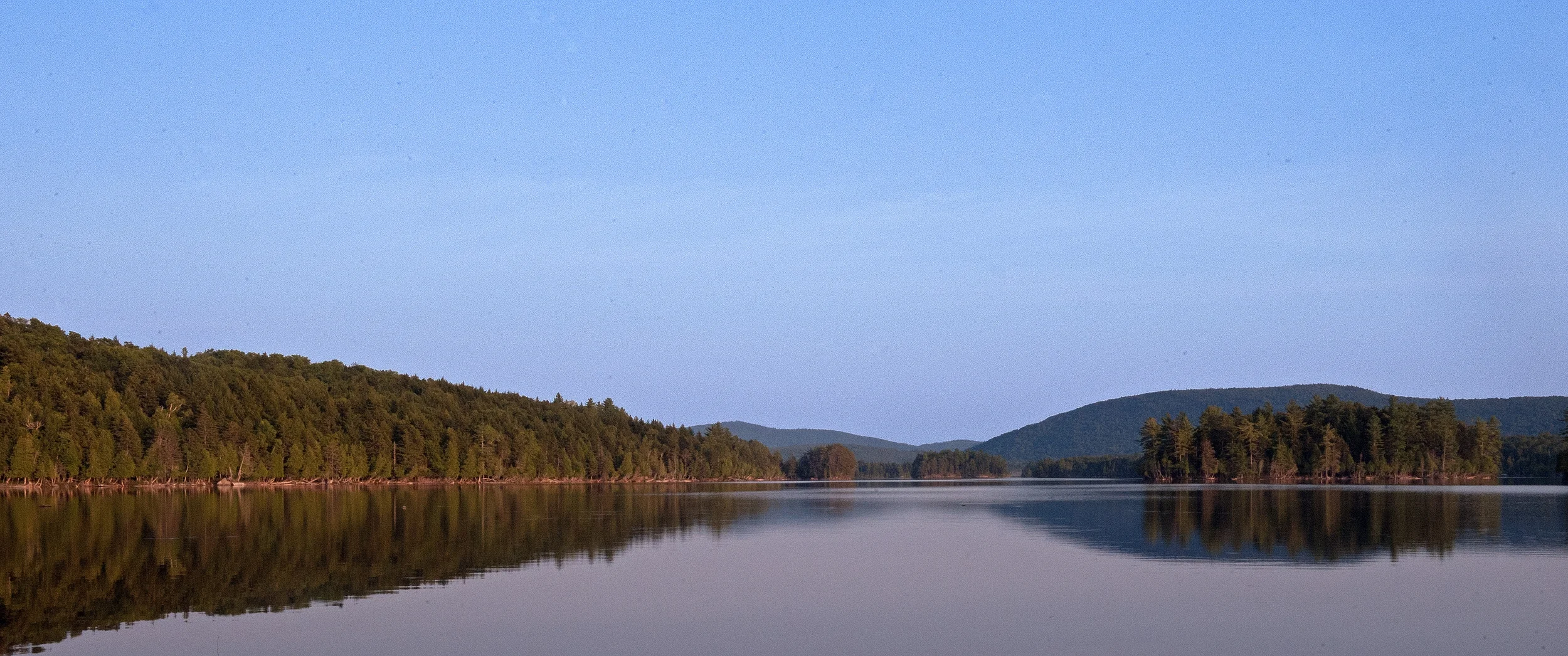
Greenville is just west of the center of Maine. It sits on the southern shore of Lake Moosehead, one of the most popular vacation hubs in a state that calls itself “Vacationland.” The 40-by-10-mile Lake reportedly is the largest fresh water body within a single state. It abounds with boats, bush pilots in sea planes, white water enthusiasts, ATV cruisers, and campers. It also is the departure point for “Moose Safaris.”

(© 2015 R J Leighton)
Around dawn and sunset, Moose roam into nearby bogs and ponds, where they graze on fresh water shoots and other plants. Unfortunately, they also sometimes think that the grass is greener on the other side of Route 15 and cross the highway with little regard for traffic. “Moose Crash Area” warnings with flashing lights mark long stretches of road here.
(Next to humans, Moose are the most dangerous animals on U.S. highways, where they cause a significant number of injuries and fatalities. They’re about six feet high at the shoulder and can be almost 10 feet tall at rack top; they often weigh well more than 1000 pounds. Most of their weight is in their humped and distended body, which is supported by long, skinny legs. Due to their dark body and high eyes, drivers can miss any reflected gleam of headlights, although there is a debate as to whether Moose eyes gleam. Due to the animal’s height, a speeding car invariably hits a Moose in its long legs, sweeping its body up onto the vehicle’s hood, which often channels the hurtling half-ton of fur, muscle, and bone through the windshield.)
We hire a guide to find us Moose using her company’s van. This is a good practice if you don’t know the area well and you want to protect your own car. Generally, if you want to watch the animals in their natural environment and not poke around in canoes, you have to travel over some of the country’s worst unpaved, washboard, pot-holed, and frost-heaved roads. Moreover, these roads usually wind for miles through a boring tunnel of dusty scrub greenery. Most of the “good” sightings are at remote locations on a pond or in a swamp. And, we have to get to these spots within the “good” hours between about 4:00 p.m. and dusk. This means that most of our precious time is spent driving over ruts to the current "lucky spots."

(© 2015 R J Leighton)
We initially travel for about 45 minutes just to get to one of those rutty old roads, which we then rattle down for about another 40 minutes. We finally stop at a not particularly special looking place and enter the woods. At the end of a descending path, the trees open up and we suddenly become part of a stunningly beautiful vista at the edge of First Roach Pond. We wait for a hungry Moose to step out of the woods on the far shore. The only things that come out of the woods here are other Moose-seekers who, with difficulty, portage canoes into the still water. In doing so, they make plenty of unnatural noise. We decide to leave, very much worried about our disappearing time. It’s about 5:30 p.m. now and the only mammals we’ve seen are tourists. (At first, we hoped to see a big Bull Moose and Cow near each other, or a Cow and her calf together. At this point, we would settle for a glimpse of a calf's butt.)

(© 2015 R J Leighton)
It’s about 6:00 p.m. when our next rutted road opens onto Lazy Tom’s Bog. Again, the transition is startling: this is a beautiful glade with a meandering clear stream. And, there he is: a young male Moose with a small rack, dipping his long snout in the stream and munching grass shoots. He’s about a quarter of a mile away. He strolls away upstream, eating all the way, and disappears behind a bend.
We return to the highway, zoom to another rutted country road, and rumble to the end. There, at the end, is Prong Pond in the golden light of a fast-descending sun. It’s spectacular. But, people are noisily winching their motor boat out of the water onto their boat trailer. This is not the kind of thing that a respectable Moose abides at dinner time. Our daylight is fading fast.
Our smart guide reminds us that we have achieved our basic goal of seeing a Moose. She says that, if we leave Prong Pond now, we have time to go to Greenville's Blair Hill and see a glorious sunset. This sounds better than watching a boat being winched. (Besides, we now realize that we have to work more on aligning our patience and satisfaction thresholds. After all, one Moose in the camera is worth two in the bush.)
We speed to Blair Hill, which overlooks a vast area of Moosehead Lake. The sun, wrapped in a rose-tinted cloak, is sinking below thick threads of back-lit clouds; the Lake‘s high peninsulas and long islands gradually are turning into massive blue-black alligators slowly entering the shining water. Satisfaction arrives.

(© 2015 R J Leighton)
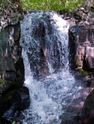
We stay in Greenville overnight, eat dinner at Kelly's Landing and breakfast at Auntie M’s, see a few interesting sights in the “downtown” area, and take a short trip up to a nearby ridge in the mountains. We're looking for Goodell Falls along the Appalachian Trail. We find the Trail entry signpost. It contains a skull and bones symbol: the warning that there is dangerous hiking ahead.
(© 2015 R J Leighton)
The Appalachian Trail at this point is only about 60 miles south of its terminus at Maine’s Mount Katahdin. But, they are among the roughest 60 miles on the 2100-mile trek. Nonetheless, getting to Goodell Falls is a relatively easy (though steep) descent. We pay our respects to Mother Nature with positive murmurs and travel home over the mountains through spruce forests and down into the plain through fields of golden rod, hay, and corn.
You can join us on a 40-second virtual tour of these happy two days by clicking the link below. (We recommend that your initial screening of the 33 images be in full-frame on your computer monitor. To make that happen, click on the featured [largest] image on the gallery page to which the link will take you. Use your left and right keyboard arrows to go back and forth; press Esc to return to the thumbnail gallery.)
Here's the link:
https://leightons.smugmug.com/Maine/Out/Vacationland/
Cheers,
Barbara and Dick